June 2020. This is the beginning of our big adventures. The first full week of this month would have us ride across South Dakota (RASDak). In July we would grab our touring bicycles and ride around Iowa. But the novel Covid-19 pandemic put those plans to rest. Well, just RASDak as it was postponed until 2021. We never had any discussion of our version of Ragbrai (July's ride) beyond the night we met for the route announcement. But Mary and I have used our Covid time to visit trails we'd never been on before or ones we had not ridden in decades. We started thinking about future rides. More importantly, Mary's Heroes never cancelled their PTO for June. Joe is retired. I, being furloughed from work for the foreseeable future, had all the time in the world. Donnie suggest that we meet and talk. I had a route already cooking.
One trail we always discussed for years was Minnesota's Root River Trail. Also included in this discussion would be an excursion into Wisconsin for the Elroy-Sparta State Trail. The deal breaker or obstacle would be transportation. We could fit in either Donnie's truck or Nick's Jeep and pull a trailer with bikes and gear but one person per day would have to drive the vehicle to the other end of the trail. I would prefer to just bag out and back but that would take forever and leaving a vehicle and trailer several days ride away is not comforting. Find a driver? Now I had a route that would be easy to bag but would require the vehicle to be parked at the first trail. Donnie had a better idea. Everyone drive their own vehicle to a trail and then relocate to the next trail after the ride. Insurance. If someone had to drop out the others could continue. But what trails?
My idea was to hit the north. So many trails. Wapsi Great Western Line Trail in Iowa. Cross the border and ride the Shooting Star Trail in Minnesota. Hit the Root River Trail next for a few days. Return to Iowa for the Prairie Farmer Trail. Finally head toward Waverly, IA, and do the eastern part of the Rolling Prairie Trail. All are paved. Easy riding. Options for other trails as well such as the one in Decorah and the Heritage trail. Combine this idea with Donnie's vehicle suggestion and it was a plan. Just one thing. Only a trio. Joe had a back procedure scheduled for that week and Nick was to help his son in-law bale hay.
Day I The Shooting Star Trail
 |
| 3 of Mary's Heroes. Left to Right: Donnie, myself and Mary. At the trailhead in Le Roy. |
 |
Always photograph the map with a smart phone.
|
We left Des Moines at 7 am and drove to Le Roy. Checked into the
Sweet's Hotel on west Main St. Unloaded, changed clothes, asked a local where the trailhead was and hit the trail. Something I noticed about all my Covid Rides and research hit us pretty hard. The internet does not update trail data in a timely manner. I thought this would be a 38 to 40 mile ride which is why I picked it to be for the first and a travel day. It was a 60+ miler. Not that killed us but a 20 mile difference is a huge difference.
The trail is asphalt but a bit rough in a spots and long sections, pavement cracks at regular intervals as if done on purpose but no sealant. Two areas were covered with water from recent rains. Open areas and canopy. A nice old rail bridge preserved for the trail is a nice touch. The trail goes through several towns. Adams, MN, has restaurants and bars and a gas station with a liquor store connected to it. Taopi offers nothing but places to rest and we were unaware of The Creek Bar & Grill in Rose Creek. We did loose the trail in Rose Creek. The arrow pointed straight so we did that but turned around when we realized we were no longer on the trail. Just remember the rule of thumb on rail to trails: WHERE WOULD THE TRAIN HAVE GONE? The GRAIN ELEVATOR, dummy. Found it! Also needs to be pointed out that Google Maps does not show the trail going past this town and thus the reason for the extra 20 miles.
 |
Representing!
|
 |
| Lovely! |
 |
The name of the highway not the trail.
|
 |
SKOL!!!
|
There is a great shelter between Rose Creek and Adams. It is on a slight incline now known as Norwegian Hill. Apparently, during the mid 1930s a train got buried in the snow by a blizzard and all the farmers came out to dig it out. Since all were Norwegian, they named the place after them. The rail has a shelter with Viking dragon heads on top of it.
After Rose Creek the trail is literally new. Asphalt had been applied recently. So recent that we had to get onto the road to avoid a Bobcat and a truck spraying the shoulder and far side ditch with that green grass seed slime. The man was spraying it north into the wind and even as far as we could get on the left side of the county highway we still got a few sprinkles. Now I have to use a lawn mower to shave!
This was near Austin, MN, the western end of the trail and it has full services and work is in process for linking Austin to Rochester, MN. We ventured off the SST and onto the Austin Trail System but turned around as we were soon in a residential neighborhood and had no desire to ride through that.
 |
Ragbrai tradition has that crossing I-35 is a big deal and photo opportunity. On our ride crossing I-90 was. Outside Austin, MN.
|
 |
At the time of the ride to Austin we were unaware that the drive back to Des Moines would take us through Austin. We believe this is the overpass we rode over several days earlier.
|
DRY COUNTY...THIS AIN'T THE SOUTH We needed to reload the coolers. Not that we were drinking a lot it is just that we did not pack enough for a 60 mile ride. So we stopped at a gas station across I-90 on our way out of Austin. We found pornography and CBD oil but no beer. "It's a dry county," the clerk explained. What? We are not south of the Mason Dixon Line! "No beer sales from gas stations." Later we found out that this is true. But it may be due that only 3.2 beer can be sold in gas stations so why bother. OK this may stop some people from making a purchase and getting lit enough to crash their car and kill but a true alcoholic or Minnesotan would learn how to avoid running out of beer. We barbarian invaders from Iowa had to conserve their precious deadly cargo until we returned to the liquor store in Adams.
We did ask a local outside the gas station. He verified this was true. He rolled up on a old school red Schwinn cruiser. Judging by his missing front teeth he knew a thing or two about intoxication. We asked him where we could purchase a 6 pack.
"On the other side of the lake, you know, the lake, there's a licka sto."
"There's a lake we have to cross?'
"Yeah, you know, the lake. Take the road. Watch out for construction but you can get through it. On the other side of the lake. You know the lake?"
"How long would it take you to ride there?"
He thought about it. "It's just on the other side of the lake, you know the lake? Maybe 5 to 9 minutes or so."
We did not know the lake but had enough for one beer break before Adams. Time to get rolling. Stopped at the shelter and drank our last cold ones. Reload in Adams. Stopped at a trailhead picnic table in Taopi and had one more while watching the man across the street rev up and drive his race car. One hour of daylight left. Mary and Donnie neglected to bring their lights. 'Don't need lights for a 40 mile ride." Back to Le Roy. The lack of lights ensured that we had dinner.
 |
The Lord Le Roy Burger with a side of cole slaw from the travel Lanes & Supper Club.
|
Once back in the overnight town I suggested that we ride directly to the tent set outside the Travel Lanes & Supper Club, the bowling alley and liquor store--your one stop shop for fun!!. We saw this on the drive into Le Roy. The naive person in me said "hell yeah, street party! Donnie checked it out before our ride and found out that they would be serving food. In reality, it was the only place for us to get food in Le Roy because of the pandemic. The day before they were allowed to open with outside service only. Since this place uses the side street for their summer fest they knew the routine although no band. Two tents, tables and chairs and a portable bar. We still had a little bit of daylight left so it was not quite 9 pm. All the tables were full so we asked if we could use our own chairs in the shade. Mary had a grilled chicken sandwich, Donnie, I forget but it came with a salad and I the Lord Le Roy Burger to keep with my habit of ordering anything named after the town. Michelob Golden was the popular beer and later we had cocktails. The place was populated by locals who were allowed to go out and drink, something we had been able to do in Iowa for a few weeks. A few of them were in Harley Davidson regalia. Some of the women were quite loud. Everyone seemed to know each other. Before our food arrived a table was cleaned and sanitized and we were seated properly. After dinner we had another round they returned to the hotel.
Haul bikes up two outside flights of stairs. Shower. Dress. Need water. Leave the hotel to walk to the gas station for cold bottle water. Two, I felt dehydrated. It was nearly 10 pm and they closed at 9 pm. Suddenly a police SUV came flying into town with sirens and lights on followed by an ambulance and a fire truck. Turning myself in the direction of their travel I saw that they were near the bowling alley. It took the next two days to piece the tragedy together. Apparently, some dude on a motorcycle with his young girlfriend on back had a bad shift, 3rd to 2nd, while popping a wheelie and she fell off. No helmet. Convulsions and non-responsive. Took sometime to make the call for helicopter in to take her to Rochester. He was arrested for DUI or OWI. She has two little kids. The one thing she has going for her is that she is young. God, please help her. Please help her children. This became the gossip. No one spoke their names.
About the hotel. It was nice. We had a Jacuzzi in our room but did not use it. They have a restaurant and bar but because of the covid and "the damn governor" they were closed. Mary and I stayed in Grandma's Red Suite. A drunken woman at the bowling alley told us that the place was haunted especially our room Not what I wanted to hear but we were not disturbed during out two nights. Several of the other guests here drove cars with Texas plates and were here as rock pickers. They would go out every day to remove rocks from farm fields. This was probably to clear fields and to sell rocks to people who decorate their yards with them. This had to be hard back breaking work. I hope they were paid well.
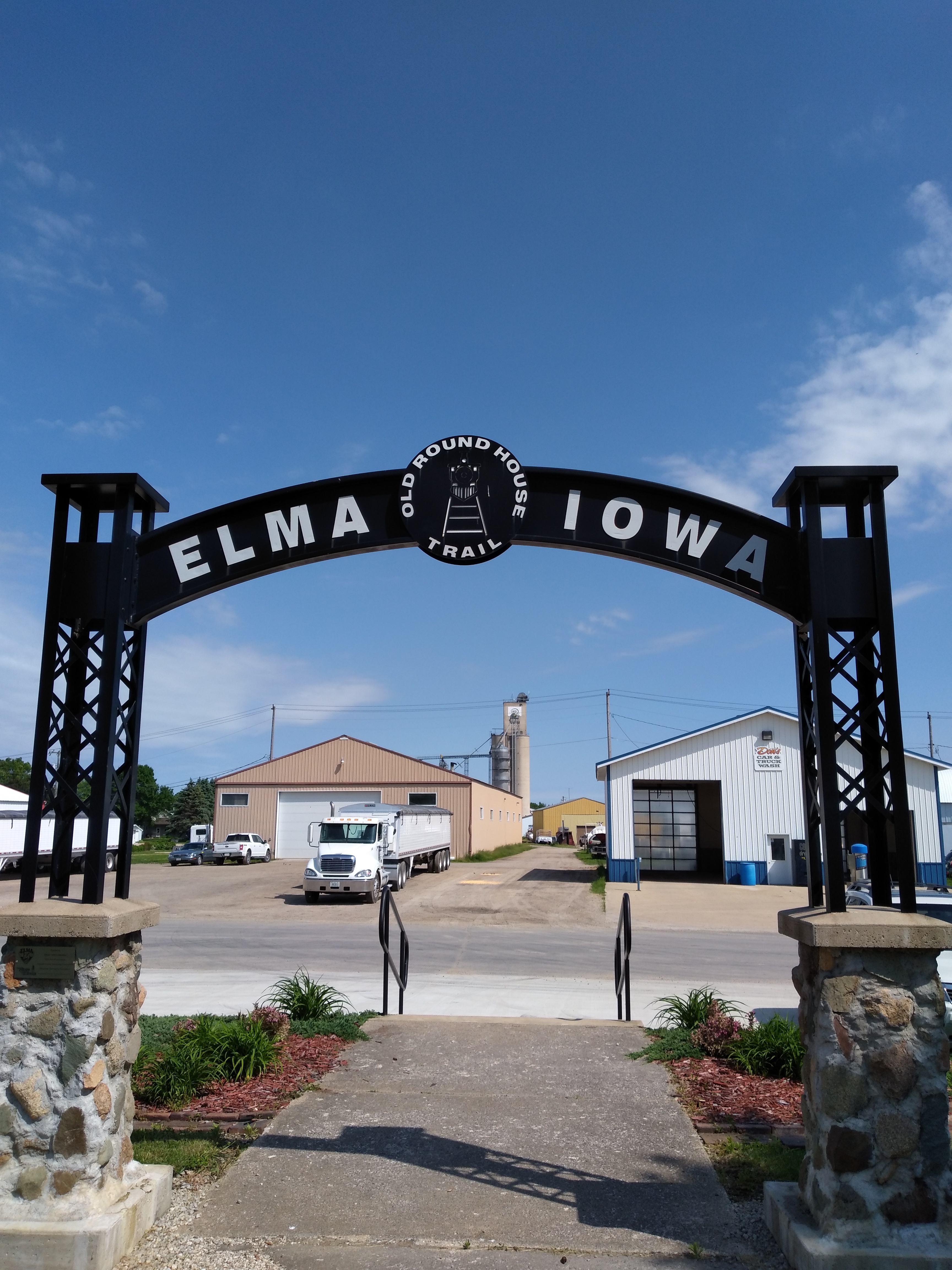
DAY II Return to Iowa For The Wapsi Great Western Line Trail
I really like this trail. This would be the second visit for Mary and I. Walk to the Cenex gas station for coffee. Listen to the gossip of the old men out front on the bench, 'I just want to know who it was, dontcha ya know." Walk back to hotel. Load the bikes into our vehicles and drive 16 miles to Riceville. Casey's for breakfast, ice and beer. Donnie stuck with Miller and Mary and I a variety pack of White Claw.
We took the south part of the trail first, Riceville to Elma, IA. Leaving Riceville the trail is essentially a sidepath along highway 9. After a mile or two the trail crosses the highway and heads south between two farm fields. One would think that this would be dull, it is not. The trail is paved and smooth. The sky is HUGE. Somewhere near Acme the trail takes a 90 degree turn toward the west, then later we resume south and then another turn this time to the east and finally south again. Our guess is that a farmer refused to sell.
Outside Elma we stop at a bench. Beautiful day! When we enter Elma we are greeted by a wonderful trailhead. Other riders are prepping for their ride north. The person that cares for the trailhead pulls up in a car and talks to everyone and ignores the White Claw in my hand. He tells us that the doors to the restrooms are automatic or always unlocked because the teens they hire to unlock them were unreliable. It is a nice building. Christmas lights are still in the trees behind the building.
He also tells us about the Round House Trail, a walking path along the old rail line that goes to the round house. We walk the path. There is a covered bridge over the road with a water faucet. On the other side there are several antique tractors and other relics from agricultural implements. We did not visit the Elma Locker & Grocery but were told it is a good stop. Nor did we visit the Blue Bird Tavern or the Elma Express gas station. There are places to get food and drink here.
 |
Made it to the finish line in Elma!
|
 |
Add caption
|
 |
| Lylah's Marsh. |
Heading back to Riceville we stop at a Lylah's Marsh County Park and sit underneath a large shelter holding many picnic tables. A restroom is available here for those in need. A family with 5 children arrive to take a break. All but one child is riding their own bicycle. That child is in a Burley trailer being pulled by the father on a hybrid. They were from the Cedar Falls area but live elsewhere now.
The rest of the trip back to Riceville was pleasant with a noticeable increase of trail users. Our next stop was at Dollar General for a bottle of aloe. All of us had sunburns from the precious day's ride. None there but Mary found some in downtown Riceville. Lunch was held at The Ville Bar & Grill. Donnie and I had rib eye sandwiches. Excellent!
We only got a few miles north on the trail just far enough to cross two rail road bridges and a shady spot to take out our chairs for a nap. I admit to being a bit disappointed but it was 3 pm and the sun was hot and north of here would be very sunny. Mary and I rode this about a month ago so just completing the south section was the real reward. We drove back, cleaned up and then drove to Osage, Iowa, for dinner at the
Teluwat Grille House & Pub restaurant. This is a great place! Highly recommend it. Donnie's idea since he was up here for business in the past. He had the "pork wings," small ribs with a lot of meat.
 |
Beetlejuice resides in the building next to The Ville in Riceville. Donnie in the reflection.
|
 |
Sign of the times in Riceville. Just keep sanitizing!
|
 |
| Mary perfectly parked her bike with just enough clearance for the tailgate. No contact between Bianchi and Honda! I do not think anyone could get closer. Trailhead in Riceville. |
 |
The Rattle Snake--blackened drilled chicken breast served over fettuccine with a creamy sauce and peppers. It came with two bread sticks.
|
Back in Le Roy, now dark, we walked back to the bowling alley. Only the owner and his son under the tent. We bought a round of Michelob Golden, tallboys this time, and talked to them at their table. He was from Elma and very proud of this region. His son was going to Winona State University to become a teacher. Dad wanted him to take over the business but he vehemently refused. We got more pieces of the motorcycle incident. Learned more about the state liquor laws and his commitment to the community. He bought round two.
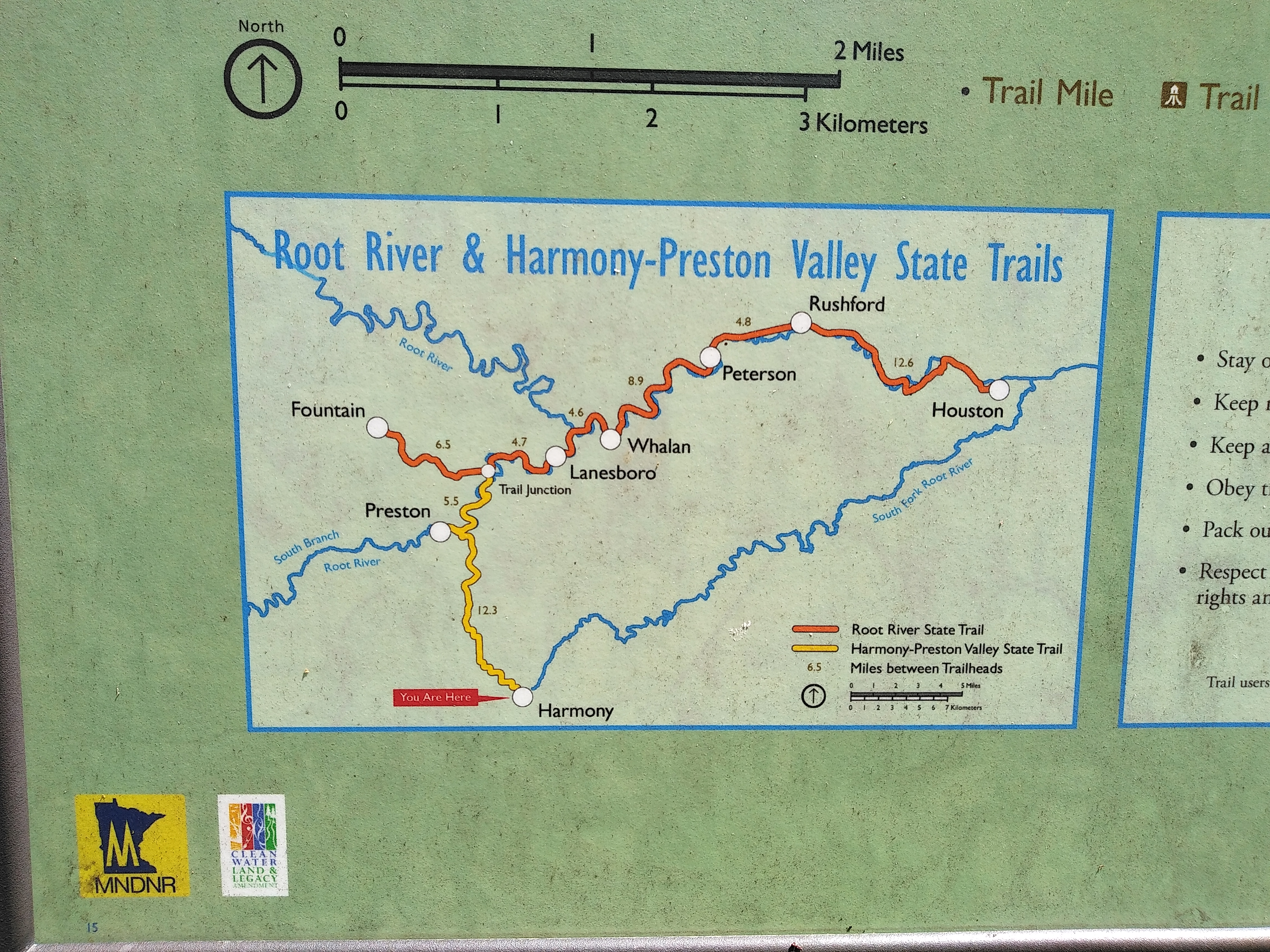
DAY III HARMONY-PRESTON VALLEY STATE TRAIL
Time to relocate to Preston, MN. This town is about 30 miles or so from Le Roy and 5.5 miles south of the Root River trail. From the
Trailhead Inn we would be able to completely ride two trails in two days. As with the arrival at Le Roy, we checked in and took off on the trail having dressed for biking back at Sweet's Hotel. Our rooms were not ready since we arrived very early but we had the keys and more importantly parking spots for the vehicles.
 |
The Trailhead Inn is built in a former school building. Photo credit Mary.
|
 |
| The Milwaukee Rail Road was an important institution in this region. Parts of the Root River Trail System was on the former lines. |
The Trailhead Inn is a former school in Preston and is located right next to the trail. An ideal location to hit both trails. We would definitely stay here again if we return to the Root River Trail System. The owners were very helpful and friendly.
We headed to Harmony, MN, on the Harmony-Preston Valley State Trail. (notice that a lot of trails here are "state" trails. Iowa calls them "nature" trails) If you should happen to stay here and ride to Harmony please SWIVEL YOUR HEAD AND LOOK FOR THE BROWN SIGN THAT SAYS "HARMONY TRAIL OVER THE BRIDGE." It's a bit confusing right off the bat but this was the only point of confusion. The trails intersect and go in various directions. Going under the bridge may see like the right thing to do but that leads to a different part of the trail that does not go very far. We were able to catch the person who made this mistake and get going on the proper section of trail. Whew!
 |
Somewhere on the "steep" section of the Harmony-Preston Valley State Trail.
|
The trail is asphalt and showing its age a bit. It has some bumps. Also when the shoulders are trimmed/mowed the debris is left on the trail. There are many curves which makes it fun. Be careful not to take a side trail that leads to a fishing spot. Preston is known for trout and there are ample opportunities along the HPVST for fishing. From the Root River Trail to County Highway 16 the trail was constructed on an old rail line. South of that road the trail follows a ridge line and is a bit hilly, steep rollers. The official map has this section in red for about 5 miles as a warning. We did not find these hills excruciating soul searching death marches, rather a rewarding challenge and enjoyable especially on the return but weaker riders and trikes and older recumbents and other assorted heavy bicycles may have a different experience. Its curvy nature creates blind spots and the mowing debris and sticks make the high speed return exciting. Fortunately for us, we did not encounter anyone in this section nor take a spill from grass trimming and sticks.
 |
| Trailhead sign in Harmony. |
 |
Downtown Harmony.
|
 |
Time for music. Harmony.
|
 |
Danger Will Robinson! Steep climbs and blind curves!
|
|
| View of the trail disappearing. |
Harmony is a nice stop. The trailhead has a park of musical percussion instruments that one can play. The town has full services, too. We had lunch at the Harmony House Restaurant. Both Donnie and I had the special: turkey dinner complete with mashed potatoes and gravy plus stuffing and rolls. Mary had the Swiss steak with mashed potatoes. We ate outside because of covid restrictions. Much later during the ride Donnie said that he rode on the turkey and when that ran out he rode on the gravy. Almost too much.
 |
Thanksgiving in June courtesy of the harmony House restaurant!
|
So we flew back to Preston and headed to the Root River Trail proper with only one stop at a picnic table after the steep hills. Did I mention that the steep hills were fun on the way back? Just like skiing. Accelerate. Watch your line. Watch out for people at the blind curves. Apply brakes and make turn careful not to slide on debris. Release brakes and resume pedaling. Up shift. Down shift. Keep head up. Smile but keep mouth shut (bugs). Here's the next blind curve. Repeat for 5 miles.
Do not go off the trail because the state flower appears to be the
Cow Parsnip which if touched can be painful in sunlight. Sometimes this plant is confused with other dangerous plants such as
Wild Parsnip and Giant Hogweed.
North of Preston the trail was busier. Bikers, walkers, runners, families ect. Not that bad. the trail was still a bit rough in places. Bridges were rough on both sides of the trail. Bad drops and height differences from the trail. We caught air on a few. After 5 and a half miles we reached the Root River Trail and took a left and headed west to Fountain, MN. this was a 6.5 mile section. Perhaps 4 or 5 of this was uphill at max rail grade. For those of you familiar with the Chichaqua Valley Nature Trail in the Des Moines, IA, area, it is similar. Canopy and incline for miles. Just keep pedaling. People coming down the trail were full smiles. Few helmets but big grins.
 |
| The Harmony-Preston Valley State Trail crosses the Root River north of Preston. It also crosses the South Branch of the Root River. |
 |
| One of several maps/signs/posters displayed around the trail system. this one at the trailhead in Fountain, MN. |
 |
| The large shelter at the Fountain trailhead. the picnic tables are extra length. Free WIFI here and the best WIFI we had all week. Also at this trailhead restrooms with flush toilets and electricity in the shelter and a water available. If I was to do a camping adventure on this trail system I'd camp here. |
Just before town there is a picnic table and what we were calling a hobo hut that we would later stop at. The trail levels off and the park is located there. Two shelters with tables, water, electricity and WIFI plus restrooms with flush toilets. Everything one needs for camping.
Karst Brewing is located nearby. A bar and a diner are also here. We did not stop at any because we needed to be back in Preston before 7 pm so we could have dinner somewhere nice.
 |
| We called these hobo huts for lack of a better term. A shelter of sorts. Several of these were on the trail. |
The ride back was almost effortless. If it was not for the constant, it never let up all week, every trail, wind there would have been no need to pedal at all. We knew why people were smiling when we were climbing and they were going downhill. We stopped at the tank just off the trail near our hotel.
 |
| Gin & Tonic on top of Preston at the Branding Iron. |
 |
| The last rib eye. hate to have the kitchen staff be forced to wrap it up, label it and store it properly for the next day. Thank you, Kayla! |
Dinner was at the
Branding Iron. Mary said we had a half our to shower and dress. We met that deadline and hopped into Donnie's truck and drove to the tallest bluff overlooking the town. Patio seating only. but we were late. They closed at 7 pm (covid hours) and it was 7:16 pm. The gentleman at a nearby table told us to sit and they's serve us. Sure enough, Kayla came out and asked what we would like to drink. Tanqueray & tonic for me. Donnie had the Dave's Burger. I had the last rib eye as I'd hate the thought of it going to waste. Our view was spectacular. The driveway was so steep I wondered how they managed it during winter.
 |
| Seems like the M-60 went out of service very quickly after the Abrams came online. This is at least the 4th we have seen on trails since the covid began. This one near the Preston trailhead. |
 |
| Purchased this in Floyd, IA, during an emergency restroom visit at a gas station. Goes well with 7-Up or ginger ale. Photo taken in Preston. |
DAY IV THE ROOT RIVER TRAIL
 |
Just after we reach the Root River Trail.
|
 |
Located at the HPVST and RRT junction. Morning fresh selfie! Reminded me of finding the Museums of Selfies in Hollywood, CA.
|
This was to be the crown jewel of our adventure. We have heard a lot of people talk about it. Destination trail. The trail itself was very smooth with the exception of the first 6 miles east of Rushford, MN. Lots of canopy to provide shade and beauty. Exposed rock formations here and there. Rail grade to save our knees and towns to meet our needs. I was missing my Century Machine, my carbon roadie. But first the 5.5 miles from Preston to the trail itself.
 |
| Artwerk at the Pastry Shoppe. |
We left before 7 am. It would be a 80 mile day. Our first stop was at the Lanesboro Pastry Shoppe in Lanesboro, MN. Donnie had the burrito and raspberry crumble. Mary and I had food from Casey's in Preston since I was awake at 5 am and needed coffee but here she ordered the raspberry crumble and I the Bumble Bee pie (fruit). Outside seating in a nice patio area.
 |
| The shelter in Whalen, MN, with the new style tables that one cannot sleep on. |
 |
| Donnie shooting hoops in Whalen. |
Whalen, MN, was our next stop about 5 miles away. Just a stop at the gazebo and a visit to the "magic kybo," I'll leave it at that. Not long after leaving town we encountered a huge tree that fell and blocked the way. Turned around and took a gravel road to the nearest access point. I wonder if this was the trail that Steve Fuller took. After returning to the trail a few miles up a tractor appeared with a front end loader presumably to remove the tree. Sure enough on the return all traces of the tree were gone. Peterson, MN, was a similar stop. Nothing appeared to be open on the early covid Sunday. Trail use was quite light. Most of the users we encountered appeared to be casual riders.
 |
| Found me father in Peterson, MN. |
Rushford. MN, is quite bigger than the other towns lining the trail thus far. There would be a 12.6 stretch until the end of the trail so we planned to refuel and rest before continuing on. Also, according to the map, there was a "steep" section marked in red. The map showed it to be a shade over a mile long. We reloaded at the IGA store. Water, Gatorade, bananas ect and then rode to the bench just east of town.
 |
| The bluffs begin after Rushford, MN. When asked when the steep section would begin I replied that when one of those bluffs got in the way. I think that was in 8 miles from here. it was at this stop that I fixed Mary's bike. |
 |
| I renamed this town Slowford because of all the cars that delayed us from cross a road. I know I know, check my privilege. My attitude was definitely affected by how poorly I felt. Tummy ache. |
Here we noticed that the rack on Mary's bike was moving too much. A bolt was missing probably due to the bumps we had rolled over all week. Simple solution was to remove a bolt from her seat tube bottle cage and reattach the rack. It held for the rest of the trip. This was her Bianchi's first long excursion and she was carrying our cooler. Pro-Tip: always carry extra bolts.
Time to roll on to Houston, MN, the last town on the trail. First 6 miles of a rougher trail surface. Nothing bad, mind you, but enough to keep a watchful eye. Then the steep section. First the sign appeared to warn us and then our legs felt it. Gravity. It was not bad. Perhaps better than its counter part on the Harmony-Preston Valley State Trail. At least much shorter.
 |
| At the natural Park at the nature Center in Houston, MN. |
 |
| Mary's bike at our lunch stop in Houston. Of note is the Celeste handlebar wrap. |
 |
| Nice bicycle sculpture at the nature center in Houston. Locals told us to stop by. |
Two stops in Houston. The first was at
Barista's Coffee House. Then at the
Houston Nature Center. We had to order through the drive thru window. Their special was a 1/2 sandwich and chips for $6.50. Mary had the special and a soda and I a whole Reuben and a iced espresso. Bill was $16 which was quite reasonable. Donnie had a whole sandwich and chips and a drink IIRC. Seating was out front on their fairly shaded patio. The nature Center was a good stop. Air conditioned restroom with paper towels and flush toilets! The "natural" park was a nice stop for us to rest while we were there.
The ride back was good. The steep section was fun. We stopped again in Rushford at the IGA for water. Rolled through Peterson but stopped in Whalen for the magic kybo and Donnie shot some hoops with the basketball at the shelter. We talked to a couple who had their 10 y/o granddaughter on her new Specialized road bike. The Grandfather was wearing a Ragbrai jersey from 2019. Said he only did that ride once. Along the river we saw and heard people on kayaks and tubes enjoying the day.
Lanesboro was a great stop. It was time for a beer or 4 since it was not only the last town out but a mere 10 miles away from home. The town was crowded with people carrying their tubes back to the outfitters. But the real issue was finding a bar that had shade. We thought we found one but the proprietor was not happy with the place we parked our bikes and asked us to park out front. After 75 miles and in this heat I resisted the urge to speak my mind. She was probably right. But I vote with my feet and money and she lost. We complied but across the street where that proprietor welcomed us and said we could sit inside with the a/c because she was open to 25% capacity. We always go where we are welcome. Dropped about $100 at the
Pedal Pushers Cafe between beer and a jersey I purchased. Great selection of beer including Grainbelt on tap. Photos of the Dirty 50 on the walls. I wonder if Fuller was in one. Definitely will return and perhaps order food the next time we roll through.
For some reason I decided to burn all my energy reserves with 3 or 4 miles left to go after we turned onto the HPVST. Big ring. Drops. Breathing. The jagged line between pleasure and pain. Do not cross the lactic threshold. Would have been perfect if I had a cocktail in hand when my partners finally rolled up to the hotel.
 |
| Somewhere on the trail. On the way to Houston we saw a huge snake. On the return this shy turtle. |
 |
| The return selfie at the aforementioned selfie station. I was too tired to learn how to use the timer on my new phone. |
 |
| What these signs really say is that the transition from trail to bridge could possible be very rough sometimes involving 10" drop offs or bumps. |
Speaking about food, we rolled the remaining 10 miles, showered and put on clean clothing and ate at the
B & B Bowl and Restaurant. I gave in and ordered the waffle chicken sandwich which was quite good despite the strange texture of waffles instead of bread.
DAY V RETURN TO IOWA AND RIDE THE PRAIRIE FARMER
Joe and Nick had been communicating with us. Nick's hay baling fell through because remnants of Hurricane Cristobal were heading toward Iowa with a promise of 1 to 6 inches of rain. Joe thought he'd be able to ride after a doctor shoved a huge needle in his spine to inject him with something to kill his back pain. This procedure was to be done today and they'd leave the doctor's office and meet us in Cresco, IA. Other people used the term hurricane to describe the oncoming rain. Having not watched television nor listened to news radio for days or read a newspaper we were relying on gossip. Finally a hurricane with my name on it albeit the Spanish spelling of my name. There once was a tropical storm named Christopher but it amounted to nothing much like my life. So it was going to rain and we were expecting company. Time to leave Minnesota.
The drive to Cresco was short. 30 40 miles. We left early. Upon arrival we drove to the Cresco Motel and woke the innkeeper up to ask if we could park here and complete the registration when we were done riding. Sure, park anywhere he said to get us out so he could go back to sleep. Works for us!
The Prairie Farmer Trail is a paved 20 mile trail connecting Cresco to Calmar, IA. Ridgeway, IA, is the only town between the trailheads and is the halfway point. there are many small shelters along the path several of which are Eagle Scout projects. About a mile north of Calmar there is a little park that displays rail road signs and tells what they mean. Sadly, a dead fox was here. We do not know what killed it.
The trailhead in Calmar is nice and has a proper restroom with flush toilet. There are artwork here as well. A trip into town reveals that there are several bars and restaurants but all seem to open at 4 pm. A Kwik Star provides the food and drink needs of those who bike in. The road at the end of the trailhead seemed busy and a sign shows that US 52, Iowa 150 and Iowa 24 are the highways using this road. I had a strong desire to cross the road to take a photo of a mural painted on the side of a building but every time I looked a parade of cars, trucks and semi's was prohibiting such a move. Instead, we got drinks and snacks at the KS and rolled back north. The sky was getting dark.
 |
| The Hidden Outhouse at the rail Road Sign Park just outside Calmar, IA. |
 |
| Welcome to the trailhead in Calmar. The end of the line. |
 |
| Donnie found The Bar in Calmar. Unfortunately, or because of the impending hurricane it was fortunate, for us that it did not open until 4 pm. |
 |
| The Freedom Rock at the trailhead in Calmar. Notice a paramedic/First Responder included. |
 |
| The namesake of the county on back of the freedom rock. |
Stopping at the shelter outside Ridgeway for the second beer break may not have been the best idea but then again the rain would have found us anyway. On our first stop here a city worker pulled up with his lawn mower to mow the ditches along the highway. We talked to him a bit. Apparently he worked for a construction company that did part of the "Lanesboro" trail (Root River). He also related his experience on this trail when Ragbrai rolled through Cresco.
Our second stop was a one and done. We were feeling the occasional sprinkle. Cristobal was on the way. 10 miles to go but they were not dry miles. It was not a hard rain but a soft rain that slowly got stronger. The trail and roads were completely wet as was our bikes and rain gear. Get checked into our rooms, shower and change and then find a place to eat.
Fat T's Cafe was our lunch stop. Interesting name. A nice little sandwich shop and coffee place in downtown. Eat and return to the motel and nap until Joe and Nick arrive. When they did get here we placed our chairs underneath the overhang and drank beer and discussed where we should ride tomorrow. It was decided to drive to Wisconsin and ride the Great River State Trail starting in Onalaska, WI, near La Crosse, WI. Donnie's idea. None of us have ever been there and it would be a prelude for the Elroy Sparta Trail we'd like to do. Of course it was time to eat again.
Cuautla Jalisco Mexican Restaurant and after dinner drinks at The Pub.
DAY VI WISCONSIN BOUND & THE GREAT RIVER STATE TRAIL
The rain ended while we were at The Pub. By 7 am the next day and the sky was still grey as we left Iowa for Wisconsin. I remember getting on top of a hill and looking down at the clouds thinking that we were going to drive into a lake. All of a sudden our phones popped to life as we were close to La Crosse and data coverage returned. We had voice and text all week but needed WIFI for internet and such. Note to readers: When using Google Maps for directions to a trail be sure to type in "trailhead" into the directions. Joe said that Google kept saying that we had arrived but no trailhead in sight. A wrong turn into a factory and around the buildings. Finally we stopped at a wood finishing business and asked if we could park here. They allowed us parking privileges. Pull the bikes out and ride.
We headed downtown first to look around. There we met a local rider who was only too happy to show us around and lead us to the trail and even told us how to get back to tour vehicles. "Turn left at Culver's and there you will find the trail that leads to your cars." He was right but we had moments of doubt.
 |
Donnie and Nick at the Hiawatha statue. La Crosse.
|
 |
| credits |
 |
| Sorry, kids, river boat closed! |
 |
| Nick on the right and Jim on the left. Jim was riding in the same area as we were and we convinced him to lead us out of the riverfront area and guide us to the Great River State Trail.. It was on his way home. |
 |
| That sky! La Crosse, WI. |
 |
Mary and I.
|
The Great River State Trail is not paved and was wet from yesterday's rain. It got even wetter from today's rain. The surface looked like an old road, clear in the tire tracks but grass and weeds in the center. No problem, we have rain jackets. Although it is called the Great River State Trail we did not see much of the river. We were in canopy following what looked like an old Jeep trail but smoother. The issue with the trail were the few places where it was muddy and slick and our rear tires would slide. A long rail bridge at Lyle's Landing provided a beer stop. Beautiful old bridge. There were not many trail users out that day probably because of the rain. There was a light rain to a mist most of the ride. We turned around in Trempealeau, WI, after eating at the River Cafe. Another bridge beer at Lyle's Landing before the hunt for our trucks began 7 miles later. Our friend was correct, turn at Culver's and take a right on the trail. What saved us was recognizing the factory we toured on accident while looking for the trailhead in our vehicles. We learn from our mistakes. End of the ride.
 |
A wet beer bridge beer.
|
 |
The railings went on and on.
|
 |
Our lunch destination. Highly recommended by us.
|
 |
Exclusively at the River Cafe, The Trempealeau Mountain Climb. "1/3 lb fresh Holmen locker burger starts the climb, topped with American cheese, a slab of ham, two slices of applewood smoked bacon and top it off with a fried egg."
|
 |
| Our bikes were filthy from the wet trail. On the bridge Nick bent over to wipe muck off his bike and I thought he vomited when I spotted the pile it left. |
Time to bid farewell to our friends and teammates. Joe and Nick were headed to Lanesboro where they would ride to Fountain and back that evening and stay at the Iron Horse Inn. The bar just opened and they were getting 2 beers for the price of one. Donnie, Mary and I headed to I-90 to intercept I-35 and head to Des Moines.
Would I go back? I would love to hit the Root River Trail sometime in the future. Perhaps in Autumn. Love to hit that area after the pandemic ends so we can experience it without covid restrictions. I do admit, however, that I enjoyed the silence and isolation.