Wednesday, April 29, 2020

The Covid Files #5 Rides of Isolation The Wapsi Great Western Line

Looks like a hamburger with a railroad crossing sign and a tree in it! Just my opinion.

I forget how I became aware of the Wapsi Great Western Line Trail.  It may have been a news article that popped up in my Google news feed last year.  Something about a recent completion.  Something about being close to a trail in Minnesota.  Paved.  Someday I thought, someday I'd like to visit that trail.  Someday was Monday.

The trail is a paved and is 27 miles in length.  There is a gravel section but it was less than a half mile in length.  The north section ends at the state line just 1 mile shy of Minnesota's Shooting Star Trail.  The southern terminus is Elma, Iowa.  The interesting fact is that the trail is based on the Chicago Great Western Railroad.  That is the same railroad that the Great Western Trail in Des Moines uses and the Chichaqua Valley Nature Trail uses.  I took a photo of a Kansas City Mile marker that is of the same design on the latter two trails.  Unlike those trails, the WGWLT is curvier.

We started late.  Should have left the house by 5 am or 6 and gained a few hours of ride time.  It was a long drive up north, over a 300 mile round trip but as the sage says you only get to do it once and I'm sure I'll be back at work soon enough and my opportunities for road trips to obscure low populated areas of the state will be limited.  The plan is to ride empty trails on Monday, the day Mary has off from work.  This locale seemed perfect.  Oddly enough we discovered another trail in Osage, Iowa, that runs to Mitchell, Iowa, the Cedar River greenbelt & Harry Cook Trail.  Had we more time...

Mistake #2 was starting in the middle of the trail.  Seemed like a good idea at the time.  Riceville, Iowa, has services, a Casey's convenience store.  Grab a bite and ride to the north end.  Return and grab another bite and drink and ride the south part of the trail to Elma, Iowa, and back.  But the wind, the never ceaseless wind was our nemesis.  The thought of another 12 miles into a headwind was enough for us to call it quits.  Needed to get home.  Another time...

Like most places during the covid pandemic, closed.

At the Casey's we asked the clerk where the trailhead was assuming that there would be parking there.  "Just down the road near the campers."  Nope.  Two spots and one was for handicapped folks. The real parking is just a block south of there.  We discovered that later.  Instead we parked on a side street across from the Windy Tree Cafe.  That should have been a sign.  It was windy.  This part of Iowa is very flat.  Wind farms are abundant.  Gates to close Interstate 35 during blizzards are up here.  But we drove over 150 miles and we were here to ride!


Riceville trailhead

Unique bicycle rack in McIntire, Iowa.


Nice looking trail head.  I took a photo of the map.  You never know if you will needed.  A few benches and then a curvy section under trees that leads to Lake Hendricks campground and a few more curves to get the trail righted and orientated to the town of McIntire, Iowa.  The curvy section does allow one to get used to trail signage which is important.  Big "rail crossing" like signs that say Wapsi Great Western Line are the sentinels for trail users. along with blue markers.  Mile markers are stone obelisks with the mile number and a round WGWL symbol.  Blue signs with numbers mark every intersection. Often when the trail does not cross a road in a normal fashion so one needs to look for the "rail crossing" sign.

These can also be found on the Great western Trail in Des Moines and the Chichaqua Valley Nature trail in Bondurant.  I'd love to become a billionaire and piece this together for one trail that ends in KC.

Several miles into the trail an old remnant of the Chicago Great Western Railroad appears.  It is a stone sign indicating that Kansas City is 412 miles away.  We have seen these on the sister trails before but never one over 300 miles away.  Stopped for a photo.  An old bicycle with a "3-Speed" sticker lays there rusting away either as a piece of refuse or a trail decoration.  We stop for a photo and another couple comes riding by from the north.  They are from Mason City, Iowa, and are here for the first time.  They inform us that the wind is much better on the return and let us know that we may see an Amish horse and buggy.  I never knew that there were Amish this far north but then again not much development nor population is here.


Fun wooden bridge!  Watch that hard right at the end.

The next excitement are in the form of two old rail bridges that the trail uses.  One has a tar rock surfacing over the planks with the center bare for those riding.  The other looks like it has recently been restored.  As we roll on the trail takes a left and in a gully is a wooden pedestrian bridge.  Watch your speed here.  A hard right is required at the bottom of the bridge and some planks are sticking up.

The town of McIntire, Iowa, is soon reached and the trail disappeared.  We roll on the road and head out of town searching for the rail crossing sign to no avail.  Cut through town and do not see any indication that the trail exists.  Finally we ride back to where we popped into town and look again.  Just barely visible is a grey sign about the size of a "one way" sign that has an arrow and the WGWL emblem.  BINGO!!  They changed the sign.  We follow and there are tons of these signs pointing the way.  When the trail resumes we see the classic rail crossing sign.  Note: in town signs are different.  It is here we see the Amish farm.  Fields are plowed.  Women and children hanging laundry on the clothes line.  Somewhere we see a young man riding in a buggy.

Continuing on we ride through a forest, Pinicon Alders Wildlife Area, and there are cabins but later we emerge into a wind farm.  The trail surface is new and concrete no longer asphalt.  In this area we need to take about a half mile of gravel.  The gravel is also relatively new or underused so finding a "clean" line through it is difficult.  But a nearby treeline holds the paved trail that leads to more wind turbines and eventually a hog confinement.


Without glory or fanfare the trail ends.  No signs, no trailhead.  Just stops.  To be fair, this section is new.  We ride the gravel road half a block to the next intersection and look north.  Stateline Rd.  We are at the Iowa/Minnesota border. One more mile of gravel a there is a paved trail waiting for us.  But it is windy and we are on road bikes not suited for this rough stretch of road.  We cannot see the trail from here.  We can only see the gravel road and flat fields.  Time to turn around.  Next time...

The strangest thing about these rides of isolation on obscure trails is that we never see anyone, well the odd person or two like our Mason City friends, until we turn around and head back.  Sure enough after exiting the wind farm several families with kids of all ages are assembling in the tree line.  On foot and on bike.  Mary thinks they were the people from one of the cabins we saw.  By the rock quarry we encounter a woman out on a run and nearly gave her a heart attack when I announce our presence and desire to get around her.  After returning to town we rode out to the other section look at the south trail and we spotted a cyclist riding into Riceville. And I'd be remiss if I failed to mention the man waling two dogs near the trailhead of Riceville.

True to what the Mason City people said, the ride back was better.  Still we were tired and it was getting late.  We talked about making this a weekend trip and camp or rent a motel room so we could enjoy this area more and push it into Minnesota and the Shooting Star Trail and visit the trail in Osage, Iowa.  If you have the time check this trail out.  It is nice.  I recommend it.


Sunday, April 26, 2020

The Covid Files #4 Rides of Isolation Ishmael on The Cinder Path

Chariton trailhead.

It was the weekend again.  Saturday.  God bless Saturday!  But weekends here especially in nice weather bring out large numbers of trail users.  During the pandemic this is dangerous.  Asymptomatic runners, dog walkers, families and cyclists filling the air with invisible virus infection that everyone who encounter those deadly clouds of exhale breath...  This day we flee the city to social distance ourselves.  Our destination: The Cinder Path.  Chariton to Humeston, Iowa.

This would be our second visit to this trail.  Our first was during the 2016 edition of Ragbrai.  We started at the southern terminus, Humeston back then.  Looked like a great idea at the time.  Leave the 20,000 Ragbrai people behind and cut up north toward home on a trail we never explored before.  Sure, its surface is crushed rock but we have ridden many miles of gravel roads this week.  Besides, loaded touring bikes absorb the bumps.  We got a little over 3 miles before turning off and catching Highway 65.  A beautiful highway with 4' wide paved shoulder and on that day a trail wind!  It felt like the bikes were turbo charged.  Our problem with The Cinder Path was that most trail maintenance is done with a lawnmower.  Grass surface.  Rail ties had not been removed and some holes in them were visible.  All this reduced our speed to 5 mph.  The real issue was that we were on the wrong bicycles.  This was fatbike or MTB territory.  Once on the pavement we never looked back.  That adventure and my thoughts on the trail can be found Ragbrai-2016  But to be fair, we only rode the last 3 miles of the trail on overloaded touring bikes.
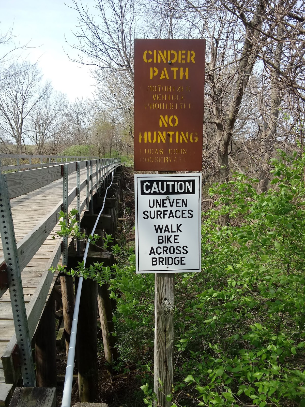
The Cinder Path

This is the first rails-to-trails conversion in the state of Iowa.  The trail was the former BC&Q rail road line built in 1872 that ran from Chariton, Iowa, to St Joseph, Missouri, and abandoned in 1974 and purchased by Lucas County Conservation Board the trail is about 16 miles long.  Mile markers are posted every .5 mile.  Our Cateye Velo 9 computer was suggesting that the signs were off a little bit on the short side.  Sources have varying mileage for the trail, anywhere for 13 to 16.  The surface is cinders and crushed limestone.  The name comes from the original surface material, cinders.  The trail is very beautiful and scenic.  There are 16 wooden bridges and a covered bridge as the trail flirts with the Chariton River and various creeks and such.  A 20' lookout tower exists or existed but we never saw it.

Our Second Time On The Cinder Path: Hit The North!


Bridge Challenge accepted.  

At Chariton.  This is the safest bridge.  A few have railings that are only knee high.  One lacked railings altogether.

As noted earlier, it is Saturday and a nice Saturday so a big day on metro trails and parks.  For some reason this trail comes to mind.  It cannot possibly be busy, can it?  Too far away from Des Moines.  I have never heard anyone talk about this trail unless I brought it up.  The consensus of those few conversations is that the Chariton end of the trail is good.  Load the tandem up inside the Honda CR-V and drive down Highway 65/69 and take a left at Highway 34.  Mostly a wonderful drive through Warren County.  We love Warren County.  Spent a lot of time back in the 1990s bicycling these empty paved roads.

The trailhead in Chariton is noted by a sign on 34.  Veer left and there it is.  Empty.  Assemble the tandem and take off.  It begins with a wooden bridge and signs telling us to dismount and walk the bike over.  Uneven surface.  Challenge accepted!  This bridge was the best bridge in terms of condition and design of the 16 we crossed.  We ride over every bridge.

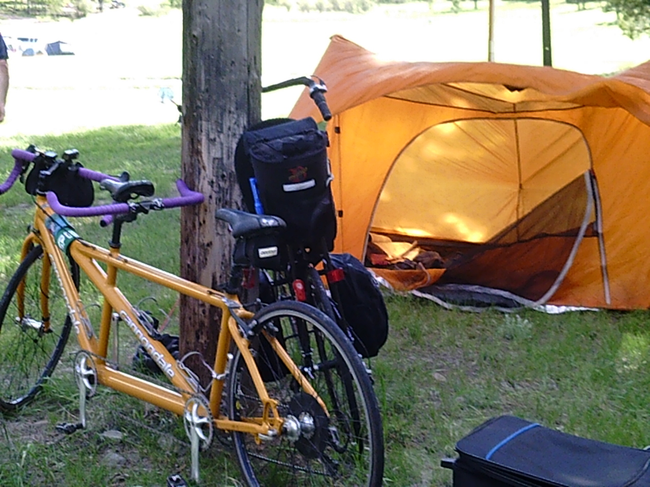
The surface is good.  A bit soft from recent rain and snow.  To correct our mistake from 2016 we ride our practically empty touring tandem sans front bags and with MTB tires at a lower pressure.  The same bike we rode for the Rolling Prairie Trail.  Carried only the essentials: tire repair and the jackets, gloves, headbands that we took off.  Keep it light.  Food would be obtained in Humeston at a Casey's.  No quarter in Derby, Iowa, but Humeston would be another 4 or 5 miles.  4 Larabars and three water bottles.  The tandem rolled quite nicely.


One of the coolest shelters in Iowa.

Walk the plank!!

I just love Iowa green in the morning sun during Spring.

First impression: What a beautiful trail!  Hidden and forgotten gem it is!  Local treasure!!  Surface be damned!  Something about the morning sun making the green flora so pretty.  We really like to hit this in the autumn.  Stunning.  Creeks and the Chariton River flowing just off the trail.  Benches and shelters for the first miles.  Our favorite is a shelter that is only accessible via a wooden  timber.  And then a covered bridge just around 6 or 7 miles into it.  After that bridge benches and shelters become scarce.

Over the Chariton River.  Signs posted at the intersections before and after this bridge stating that the bridge is closed.  Yes, it needs work and probably is not structurally safe and once again we accepted the challenge and risk.


Mary looking out the missing panel section.

The view of the river from inside the covered bridge.


All Lost After Derby

Once again I lost all sense of direction as we entered Derby 2 or 3 miles past the covered bridge.  My failure from inadequately studying the map.  The trail is generally a north to south trail but enters this town from the east.  Once in the city the trail disappears near the intersection of Stacy and Front Street.  Thinking that we were heading south I took a right and then a left on Front and headed to Highway 65.  From what I recalled from the map, the trail intersects 65 therefore by taking the highway we would intercept the trail.. Good in theory but I took another right and headed north.  After a mile and half we stopped to consult the map.  I was noon so the sun's position was of no use.  We entered "data roaming" Iowa so Google Maps were useless.  Perhaps the fact we were heading into the wind should have been a sign.  The wind was strong from the north today.  Perhaps the sign that read Princeton, MO, going the other way should have been the clue but I dismissed that.  OK retrace the steps.  Pay for the same real estate twice.  Soon enough we see a "bike crossing" sign on 420 St.  There's the trail.  3 mile mistake.  On the way back Mary noted that we should have turned left on 150th St inside Derby.

The Grassy Path

Just south of Derby, or east.  Trail quality dives...

The Last shelter.  This gem we missed in 2016, not that our team would have wanted to stop as we just refueled in Humeston and were wanting on a better surface.

The last mile or two was beautiful albeit a bit grassy.

Photo credit Mary.

Trail conditions take a dive after Derby.  The surfaces makes a transformation to a grass path.  By the time it reaches Humeston it is almost golf course quality.  Mostly between the two towns it is "the rough."  Two miles or so from Derby a shelter emerges.  It looks to be an original from 1975 and had been ignored for decades.  Yet there is a table and an opportunity to rest.  By now we have been riding in granny up front.  Had our Stimulus check been twice as large I would have suggested to Mary that we need a fatbike tandem.  But we had about 3 miles left and the surface would improve to a nicer lawn quality.  Perhaps we should have lowered the air pressure of our tires or had used 26x2.5 tires but we did not.  My arms were getting abused and our speed was nil.  The trail was beautiful and we had the option of rocketing up Highway 65 back to Derby.  Relief was soon in sight as we reached the trailhead.

The backwards sign.

CDC approved activity!
I have never seen this style on a trail before.


The Humeston trailhead is marked by a large structure holding a sign that read 'CINDER PATH."  That sign was backwards and a review of a 2016 photo shows it in the proper orientation.  Another sign indicates that the trail is 5 miles long, Lucas County section is 3.5 miles, and is funded in part from the CDC.  I guess we were following CDC guidelines.  Also of note is an ancient REAP (Resource Enhancement and Protection) sign.

I captured the Iowa flag in this.  What great fortune!

Visible from here is the restored rail depot and a wooden water tower, the last one in Iowa.  Also a campground and a M-60 Patton tank.  Ride to the tank and turn left on Front St (notice that a lot of the towns down here have Front Street as a main drag) and a Casey's General Store is off to the right.  Hoping to score a slice of pizza and Gatorade here we discovered that they had toilet paper and hand sanitizer, both the gel form and the Foundry's liquid style.  No one gave us grief for being outsiders possibly spreading the covid virus.  4 minute wait on pizza so we opted for Little Debbie triple stacked oatmeal pies as lunch.  That was the right thing to do as we noticed people were sitting in their vehicles waiting for pizza.  Casey's pizza is a big treat for small town folk even more so when all the local restaurants are closed because of the pandemic.  I'm willing to bet that no one in any of the small towns we have ridden through has had the dreaded illness.  Plenty of pizza in Des Moines.

The Ride Back

Front St is actually highway 65 so we stayed on it.  Mary had been counting cars and trucks on the way down, a good stoker duty, when the highway paralleled the trail and said roll for it.  We could ride over twice as fast into a strong headwind than we could on the trail from Humeston to Derby.  6 miles anyway with 4' shoulder.  Turning onto the trail at 420 St we completed the section of trail we missed earlier.  Unfortunately, this bit required us to lift the bike over fallen trees.  Here we encountered the first trail user. An elderly man apparently mushroom hunting.

On the way down we did not encounter a single soul.  Now we were seeing trail users.  From the highway we saw a person walking and later a van full of people stopped at a trail intersection.  I think a kid had to get out a relieve a bladder.  Leaving Derby we saw two girls walking to Derby while adjusting their iPods or phones music selection.

After passing the covered bridge we came across a family of four.  Two boys on BMX bikes and their mother and father.  Later two families walking together with lots of children.  3 young men on MTBs heading south and probably a family or two until we reached the end.  Nice to see this trail being appreciated and used by locals.  My son's GF's family lives outside Chariton and he and Kayla have often walked the trail.

A stack of rail ties.  We saw a few of these withing 5 miles of Chariton.

It was on the way back that we noticed the lack of rail road remnants on the trail.  I recall one whistle crossing sign.  At the end there is a rail road crossing sign but I am not sure how genuine it is.  Occasional discarded rail structures can be found on the side of the trail.  Piles of rail ties stacked up neatly near Chariton are also present.  But compare to many rail-to-trails we have ridden this is is not much.  Perhaps the ever present water on the sides of the trail is the reason.

Battle Damage

Look at the magnet.  First time I have ever seen a magnet holding a piece of broken spoke.

We did not get away without a problem.  Minor issues of being tired and dusty.  Right arm hurting from keeping the bike upright on the rough miles.  Legs sore, too.  But this problem only revealed itself after we made it home.  When I reassembled the bike to put it away until the next outing, I noted a piece of metal on the computer magnet.  Strange.  Closer inspection revealed that the object was the hub end of a spoke.  Further inspection discovered that it came from a spoke on the front wheel.  Bummer.  Now how did that happen.  Most likely it was not the rough section south of Derby.  Within the first five miles or so there was a fresh line of white limestone spanning the width of the trail.  On the way down I just stared at it wondering why it was there and then Wham! we hit it.  It was used to fill a hole across the trail.  Note to self:  Avoid this bad bump.  And as luck would have it I spotted the same patch in the trail on the way back.  Weird, this does not match the trail surface WHAM!  Crap that bump AGAIN!  Note to self: if the trail section changes color in a thin section of trail use caution...

Will We Return

Yes.  We conquered this trail.  Knocked down that brick wall.  I don't know about south of Derby unless on a fatty.  We think an autumn excursion would be wonderful from the Chariton end.  Of course a Spring will likely be scheduled.  Getting a motel room in Chariton is a option if libations are involved.

The back of the trail monument.  Nice to put a name and a face to someone that worked/works to keep these trails in good condition.


Friday, April 24, 2020

The Covid Files #3 Rides of Isolation New Tent Day

Without the wing.  Total ventilation!

To pass my time in self isolation/lockdown/lockup/quarantine/shelter in place I think about the future.  Can't keep me inside forever, can they?  "And even on the darkest night we could reach for the light and we could get it right." Bicycle touring season has begun although not recommended.  With all the money I am saving from not getting my haircut or going out to eat or going to bars, coffee shops, record stores ect, why not get new kit?

Why a tent?  3 reasons:

1.  Shelter in rain
2.  Shelter from insects
3.  Some modicum of privacy

Most of the time I pack one for insurance.  Easier to throw the Thermorest on a picnic table under a shelter and call it good.  In the past few years we have been staying in more and more motel rooms but now realizing how much money we are spending for that.  We have the opportunity to sleep inside schools during our South Dakota adventures but prefer to sleep outside in a tent v in a gymnasium full of bicyclists. I also like something solid in the front right pannier to play full contact touring bike if you know what I'm saying.

My other tent requirements

1.  No special unique poles that can/will/do break leaving one SOL
2.  Ability for one person to quickly assemble
3.  Ability for that one person to assemble at night and/or drunk
4.  Compact size for storage in the panniers of a loaded touring bicycle

After a decade of using the Missing Link from MSR for both self contained hiking adventures and bicycle touring I pulled the trigger and purchased a new tent.  Nothing wrong with the Missing Link,  I have two of them, but find that they take up a bit more space in the panniers than I care for and are a bit lacking in the ventilation department.

Bad Lands National Park, South Dakota, 2013.

Somewhere in South Dakota during the Faces To Falls ride, RASDaK (Ride Across South Dakota)2013.

Union Grove State Park, Iowa, 2014.

The only time we had both ML in action at the same time.  Perry, Iowa, during Ragbrai, 2013.

The Missing Link weighs 3 lbs and uses hiking sticks instead of tent poles.  I have witnessed more tents hit the dumpster or buried in the garage because of broken poles.  The ML, only needs  two 54 cm sticks of a strong material that are easy to carry.  Hence hiking/walking sticks.  Once, Mary and I got over 40 miles into a 4 day bicycle tour when I discovered the hiking sticks were left at home.  We stopped at a local store.  I wanted to use hockey sticks but Mary found cheap $12 hiking sticks.  As for stowage, the tent fits in one pannier along with a Thermorest and a sleeping bag and a few other items.  Despite its relatively small size it seems to take up a lot of room.  Great reviews of this tent can be found here.  

My personal experience.  Got mine used (barely) in 2009.  2 week backpacking adventure in the Rookies at the Philmont Scout Ranch, itinerary 32 IIRC.  Rain hard a few times.  Never had an issue.  After that it became my main tent.  Used it for bicycle touring a few times a year every year since then and whenever I went camping.  Got an offer on a second one and acquired that one just because.  Some reviewers complain about the stickiness but I find that it is only sticky when it is first assembled but once it has been up for a while the stickiness disappears.  Lastly, no special folding required, just stuff it into its sack.

The MSR Thru-Hiker Mesh House 3 Trekking Pole Shelter is my replacement for the Missing Link.  Basically a high tech pup tent.  The entire tent is mesh except for the floor and back end.  Maximum airflow!  To cover it I purchased the Thru-hiker 100 Wing.  The wing, rain fly, can be configured in many ways to protect the tent and the gear of the user.  It too is very light and compacts quite small.  Together they weigh  2lbs saving me 1 lb and precious cargo space.  To be even more minimalist I could just use the Wing only.

Still in the box.  Normal size vodka bottle for perspective.

The contents exposed.  The smaller bag contains the wing/rain fly.
The Missing Link in the Thru-Hiker box.  Need a bigger box!

Both tents in the box.  Note: The ML does not use a wing or rain fly.
With the wing on.

Please note that I did not read the instructions before placing the wing on.  Later I did and the tent looked a lot better than this.

Now I need to wait for the Covid-19 All Clear for a great new adventure.

Stay safe.  REMAIN INDOORS.  Practice safe Social Distancing!

Friday, April 3, 2020

The Covid Files #1 Rides of Isolation Heart Of Iowa trail


I have started a series of riding reports to document my social isolation on empty bicycle trails and rides throughout Iowa.  I did not possess the luxury or chains of working from home.  I am forced to go on vacation, made redundant, laid off, furloughed because of the Covid-19 pandemic.  But I have a lot of sick days and PTO that I can burn and of yesterday, Mach 30, 2020, the ability to file for unemployment.  So if this time is on my dime I will make the most of it.

Generally I ride with my wife to her work and then continue to crank out 20 miles in the pre-dawn hours.  Dark empty solitude in total isolation on trails.  But today's featured ride was a reconnaissance of a ride I am planning in honor of a friend who passed away 7 months ago.  I took Joe, my eldest son, with me who was furloughed from work as well.  This ride disturbed his self isolation of sitting in front of a screen playing with his Xbox online.  It was a zero to 45 mile wake up.  He does occasionally ride the half hour to work.  But not now nor when it is cold.  I gave him a choice, easy or adventure, knowing that there was a disparity between our levels of fitness.  He chose the adventure.  Not the first time...

Drove to Berwick to check out the roads and drove to the start of the ride in Elkhart, Iowa.  Landed the Honda at the city park.  Eric Crabb and I once rode from Altoona to Elkhart and drank at the bar.  Appears to be two bars there now and a Dr Pepper machine selling cans of soda for 75 cents.  We then sent out on a cloudy chilly day with a north wind making itself known.  Joe benefited from his mother leaving a pair of gloves in the vehicle.  The promise of a warm day once again appeared to be empty.
No vino for me!

We took NE 46th St out of Elkhart.  Some rolling hills but nothing that would kill anyone.  At the end of the road we turned left on NE 150th Ave and stopped at the winery in White Oak, White Oak Cellar.  Mary and I rode here once from Bondurant.  The note on the door said that it would open at 3 pm and if we desired to make a purchase "call first."  I did think that on the way back I would call and ask for a red and slip a $20 under the door.  "Do you take PayPal?"  Roll on, nothing here now.

I had to stop and read the sign.  Jefferson Highway.

We were still on the Jefferson Highway Heritage Byway Loop of the Iowa Byways. Never heard of it?  Neither have I.  This route goes from Alexandria, LA to Beminji, MN  In Iowa,  Lamoni to Mason City.  Jefferson Highway

Heading north our next stop would be in Cambridge, Iowa, most noted in our cycling community as being part of the Century Loop on Ragbrai and the strip club that was there when the cyclists rolled through.  Now it is a town on the Heart of Iowa Nature Trail.  In town we sadly discovered that the convenience store was closed.  This may have happened a few years ago.  I rarely ride this trail because the surface is too soft for most of my bicycles.  Joe and once rode fatbikes on this trail.  Mary and I have been on this one twice.  Once wet and once when it was 110*F.  Surface was better when it was too hot around the time of Ragbrai.  One of these days...  However, the future looks bright, The Master-Plan-.  I know I know I know, gravel junkies and fatbikers need a place to ride, too.  Joe and I elected to take the paved county roads from Cambridge to Maxwell.

Ever lose your sense of direction?  We took county road E63 out of town.  After what seemed like forever we reached S14.  OK time to turn.  But the sign said "Nevada 8 Miles."  What?  Confusion and a total loss of sense of direction.  No sun yet.  I swear we were facing south.  Nope east.  Look at the sign behind us to determine what road we were on and pull out the paper map.  Turn right to go to Maxwell Joe said.  He was right.

The bridge west of Maxwell, Iowa.

The trail intersected S14 so we decided to give a chance.  Soft yet acceptable.  Speed dropped but it was great to be on a trail.  We stopped on the bridge just before town and ate  Labars and drank a beer.  Need to reduce weight.  The sun came out briefly and we could feel the warmth.  A red SUV pulled up and the driver pulled out a MTB for a ride on the trail.  Maxwell is larger than Cambridge.  It has a Dollar General, we joked that we should stop there to see if they had toilet paper, and a Casey's.  We bought pizza slices and water at the convenience store as well as three bottles of Fireball for later.

Highway 210 has a decent paved shoulder without rumble strips.  Since we had a late start and we could ride twice as fast on a paved surface we opted for the highway.  Empty highway.  Our destination was the cemetery in Collins, Iowa, to pay our respects to Eric Crabb.  The cemetery was visible from the intersection of 210 and the road into Collins so we headed east on a gravel road instead of going into the town.

Joe 

Found Eric's resting place, said a few words and dumped a bottle of what killed him on the spot.  This poison was his favorite.  I looked to the sky to ask if he would let known his thoughts about the Great Covid-19 Pandemic and when I looked down I saw a corn cob by the headstone.  So appropriate.  He would have had a field day with the toilet paper shortage!  I could not help but laugh
.
Highway 210 and a bottle of rum.  Raise the deposit on bottles to $20 and we could provide free healthcare for all or reduce alcoholism.

A friend saw this photo and thought a 4 wheeler was at the bottom!

It was getting late.  The wind and the trail surface took a lot of time.  Now we had the wind to our backs.  210 was our choice.  Let'er rip!!!  210 all the way to Cambridge and the left turn to White Oak...tailwind.  A few good views such as the derelict Skelly oil/fuel tank and the distant fire.  Traffic was light.  We did notice that most trucks were red for Iowa State University and few were black with Hawkeye stickers for the University of Iowa.  Since we were in Cyclone territory most of them were red.


In between Cambridge and White Oak a house displayed a wooden Cessna airplane as a yard decoration.  It was been out in the elements for decades judging by how weathered it is.  Still something cool to look at.  The rest of the ride was uneventful.

45 miles.  The road out of Cambridge add miles on the way to Collins.  We had 20 miles for the return trip.  Hard to judge traffic.  Could the covid be making traffic lighter here?  Was it because it was the middle of the day?  Would football Saturday make 210 really really busy?

The Crabb Ride.  Eric always talked about a bike ride to the Haverhill Social Club.  I would like to make this a reality.   Riding from Des Moines for the Crabb Ride taking the Gay Lea Wilson/Four Mile Creek Trail to Berwick, Iowa, would increase the mileage to at least 30 each way.  Way too long for a social ride.  The Haverhill Social Club would be another 20 miles from Collins.  Looking like a solitary pilgrimage or an overnighter.  Maybe a ride from Des Moines to Elkhart since it was an old haunt of his.