 |
| Looks like a hamburger with a railroad crossing sign and a tree in it! Just my opinion. |
The trail is a paved and is 27 miles in length. There is a gravel section but it was less than a half mile in length. The north section ends at the state line just 1 mile shy of Minnesota's Shooting Star Trail. The southern terminus is Elma, Iowa. The interesting fact is that the trail is based on the Chicago Great Western Railroad. That is the same railroad that the Great Western Trail in Des Moines uses and the Chichaqua Valley Nature Trail uses. I took a photo of a Kansas City Mile marker that is of the same design on the latter two trails. Unlike those trails, the WGWLT is curvier.
We started late. Should have left the house by 5 am or 6 and gained a few hours of ride time. It was a long drive up north, over a 300 mile round trip but as the sage says you only get to do it once and I'm sure I'll be back at work soon enough and my opportunities for road trips to obscure low populated areas of the state will be limited. The plan is to ride empty trails on Monday, the day Mary has off from work. This locale seemed perfect. Oddly enough we discovered another trail in Osage, Iowa, that runs to Mitchell, Iowa, the Cedar River greenbelt & Harry Cook Trail. Had we more time...
Mistake #2 was starting in the middle of the trail. Seemed like a good idea at the time. Riceville, Iowa, has services, a Casey's convenience store. Grab a bite and ride to the north end. Return and grab another bite and drink and ride the south part of the trail to Elma, Iowa, and back. But the wind, the never ceaseless wind was our nemesis. The thought of another 12 miles into a headwind was enough for us to call it quits. Needed to get home. Another time...
 |
| Like most places during the covid pandemic, closed. |
At the Casey's we asked the clerk where the trailhead was assuming that there would be parking there. "Just down the road near the campers." Nope. Two spots and one was for handicapped folks. The real parking is just a block south of there. We discovered that later. Instead we parked on a side street across from the Windy Tree Cafe. That should have been a sign. It was windy. This part of Iowa is very flat. Wind farms are abundant. Gates to close Interstate 35 during blizzards are up here. But we drove over 150 miles and we were here to ride!
 |
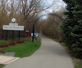
| Riceville trailhead |
 |
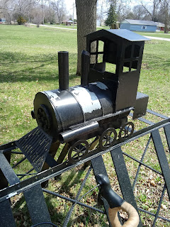
| Unique bicycle rack in McIntire, Iowa. |
Several miles into the trail an old remnant of the Chicago Great Western Railroad appears. It is a stone sign indicating that Kansas City is 412 miles away. We have seen these on the sister trails before but never one over 300 miles away. Stopped for a photo. An old bicycle with a "3-Speed" sticker lays there rusting away either as a piece of refuse or a trail decoration. We stop for a photo and another couple comes riding by from the north. They are from Mason City, Iowa, and are here for the first time. They inform us that the wind is much better on the return and let us know that we may see an Amish horse and buggy. I never knew that there were Amish this far north but then again not much development nor population is here.
 |
| Fun wooden bridge! Watch that hard right at the end. |
The town of McIntire, Iowa, is soon reached and the trail disappeared. We roll on the road and head out of town searching for the rail crossing sign to no avail. Cut through town and do not see any indication that the trail exists. Finally we ride back to where we popped into town and look again. Just barely visible is a grey sign about the size of a "one way" sign that has an arrow and the WGWL emblem. BINGO!! They changed the sign. We follow and there are tons of these signs pointing the way. When the trail resumes we see the classic rail crossing sign. Note: in town signs are different. It is here we see the Amish farm. Fields are plowed. Women and children hanging laundry on the clothes line. Somewhere we see a young man riding in a buggy.
Continuing on we ride through a forest, Pinicon Alders Wildlife Area, and there are cabins but later we emerge into a wind farm. The trail surface is new and concrete no longer asphalt. In this area we need to take about a half mile of gravel. The gravel is also relatively new or underused so finding a "clean" line through it is difficult. But a nearby treeline holds the paved trail that leads to more wind turbines and eventually a hog confinement.
Without glory or fanfare the trail ends. No signs, no trailhead. Just stops. To be fair, this section is new. We ride the gravel road half a block to the next intersection and look north. Stateline Rd. We are at the Iowa/Minnesota border. One more mile of gravel a there is a paved trail waiting for us. But it is windy and we are on road bikes not suited for this rough stretch of road. We cannot see the trail from here. We can only see the gravel road and flat fields. Time to turn around. Next time...
The strangest thing about these rides of isolation on obscure trails is that we never see anyone, well the odd person or two like our Mason City friends, until we turn around and head back. Sure enough after exiting the wind farm several families with kids of all ages are assembling in the tree line. On foot and on bike. Mary thinks they were the people from one of the cabins we saw. By the rock quarry we encounter a woman out on a run and nearly gave her a heart attack when I announce our presence and desire to get around her. After returning to town we rode out to the other section look at the south trail and we spotted a cyclist riding into Riceville. And I'd be remiss if I failed to mention the man waling two dogs near the trailhead of Riceville.
True to what the Mason City people said, the ride back was better. Still we were tired and it was getting late. We talked about making this a weekend trip and camp or rent a motel room so we could enjoy this area more and push it into Minnesota and the Shooting Star Trail and visit the trail in Osage, Iowa. If you have the time check this trail out. It is nice. I recommend it.


No comments:
Post a Comment