observations from someone who believes that bicycles are not roof or car rack ornaments
Thursday, November 12, 2020
Omaha: Trails, Bridges, Beers and Nukes
Omar
Our original intent was to see the comedian Tom Papa at The Waiting Room in Omaha, Nebraska, but 4 days before showtime he cancelled. A decision had to be made: keep our room and go anyway or find something else to do? This late in the year every trail near home had been ridden to death and with a warm weekend, 70s and dry, our trails would be crowded. Omaha has a large network or trails and bike lanes that are begging to be explored. We were planning to take our bicycles anyway so we elected to keep the room and add extra miles now that we were free of obligations. So we loaded up the Honda and headed to NE. Our bicycles were Mary's Bianchi Volpe and my Verenti Substance, both with bags for carrying locks and purchases. Mary queried whether or not we needed lights. Yes, by all means, there may be a slight chance that they would be required.
I picked the Hampton Inn Omaha Midtown Aksarben because it is located next to the Keystone Trail. This trail is 15 miles in length. It starts at Democracy Park and heads south following the Little Papillion Creek then Big Papillion Creek to Offutt Airforce Base. Guaranteed 30 miles if we stuck to this.
The Keystone trail is paved. It follows the creek as mentioned above. Scenery varies from urban industrial, residential and prairie. Highlights include a huge rail trestle that we rode underneath and the Airforce base. The trail leaves Omaha and rolls into Bellevue, NE.
Rail bridge with "debris shelter." Apparently things fall off this bridge. This was not the only bridge in the area that offered protection from falling objects. Could use benches and tables here.
Because of a sustained 18 mph south wind we chose not to head north to Democracy Park and thus spared us a few miserable miles of headwind. There was plenty of headwind anyway. Several cyclists were spotted. The ones heading north were smiling.
Keystone Trail. When not in urban or industrial areas this is the scenery.
Our first trail closure on the Keystone Trail.
Blow this photo up and you can see where the construction ends.
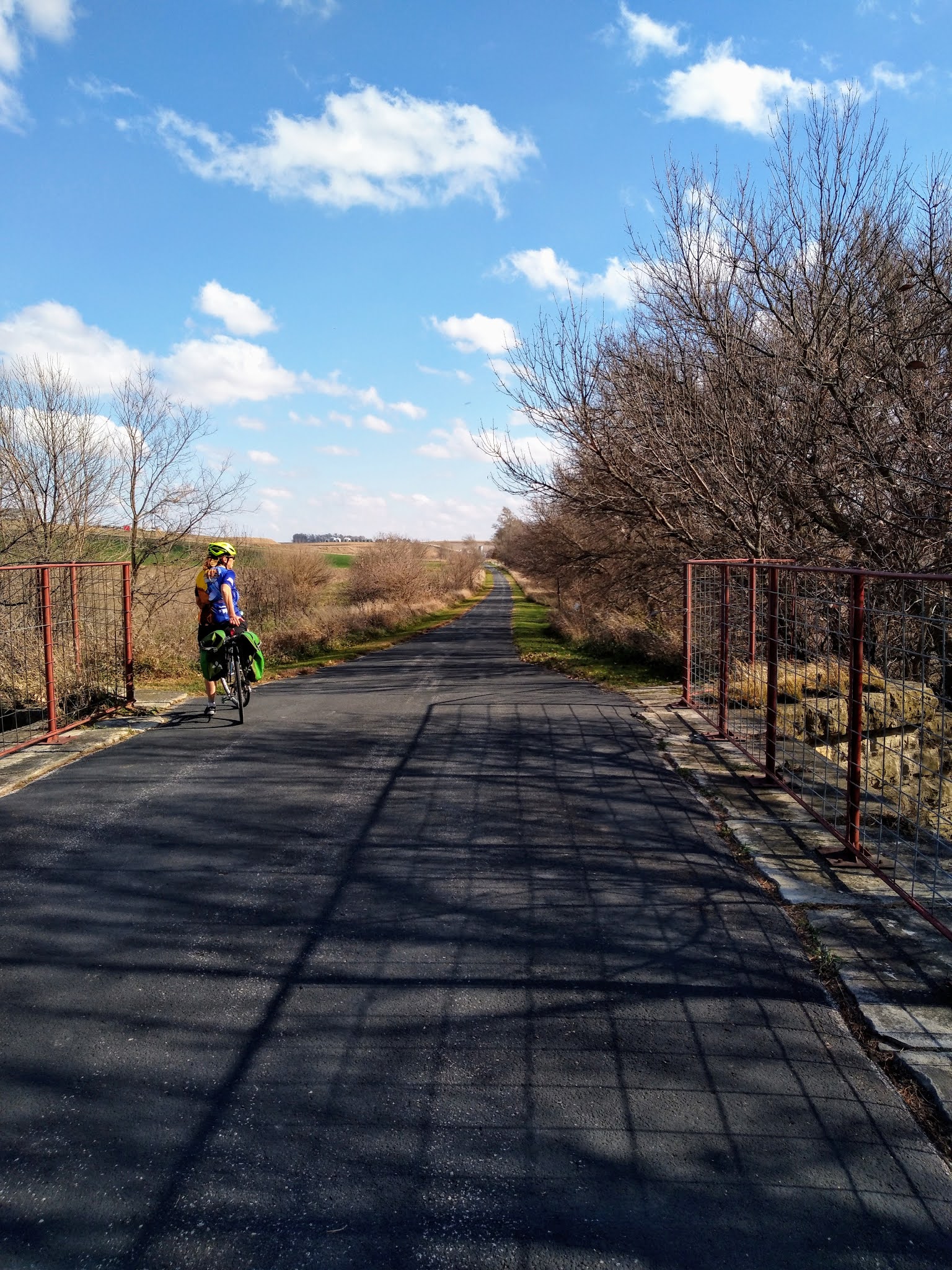
The trail is flat with the exception of going underneath overpasses and then only a short charge up the other side. The trail is also exposed on all sides. Nearing Bellevue the trail is closed. Not sure what was going on but large ROAD CLOSED signs blocked the way with orange snow fencing blocking the flanks all the way to the creek and water ditch. The end of the construction or what we thought was the end of the construction was visible but we did not want to get our feet feet. Another pedestrian/bike trail bridge could also be seen from here. So we consulted the Google and reversed course and took the road and the first left to head into Bellevue proper to get back on the trail. One mistaken turn down a gravel road that looked like it lead to a place that crossed the creek and then a short hike to the trail was regrettably taken but I got scared that when it looked a little more private property with gun rights than I felt comfortable with. So we did a mile of gravel, hip.
Once in town we got on a paved trail and saw two adolescent boys on MTBs. I asked one, "is this the way to the Keystone Trail?" "I ain't never been on that trail," he replied. Never ask a local... Another dumb move found us on a side path instead of the trail we wanted. The two boys were on the right track but stopped to climb a steep hill on foot that lead to an abandoned bridge abutment. They were so close to the Keystone Trail, closer than we were. What separated us from the proper trail was a medical plaza, empty field and a anti-tank/bicycle ditch but we found a way. Sure enough the Keystone Trail was here. The path north was blocked with TRAIL CLOSED signs on the bridge we spied from the original closure so it was best that we found the detour in the first place.
Back on the path we headed into the wind again. A few hard earned miles later we came to a trailhead. A man rode up and asked if we had or were planning to ride the trail east of here. Damn, I thought we were at the end. Please note that kiosks lack useful maps. "It's dirt," he said, "I got to the second bridge and turned around." Just as well because if we did ride to the end it would put us further east than we really needed to be. The only bad thing is that we'd would not be able to look at the Offutt from that side. I wanted to see some aeroplanes. Consult Google again and find a new route. From here to Homer's Music, one of the best record stores in the Midwest and located near food and beer. 10 miles, one hour was the estimated distance and time according to Maps. Damn, that's a long time. Food was now becoming a critical factor. We stopped at McDonalds on the way out of Des Moines, drove 150 miles or so, checked into our room and then left on bicycles. Now we were 15 miles into a ride and 10 miles from a destination that offered quarter. BUT we would now have a tailwind!
Ground Zero and The Deer
The Gate Guardian. The oldest B-52G in the USAF inventory. Offutt AFB
This place is targeted with nuclear weapons. This place controlled the nuclear missile silos southeast of Missouri Valley, Iowa, from 1960 to 1964.
Google picked the Fort Crook Rd. It had a wide marked bike lane. But first we had to negotiate another ROAD CLOSED almost from the beginning. A overpass over railroad tracks was closed for some reason. Simple lift bikes over two sets of concrete barricades and then a left onto the bike lane. Once on the lane our jets kicked in as the wind became our friend. After a bit Offutt appeared to our right. One can tell because of fencing and US Government license plates on vehicles and the use of razor wire around the grates of storm sewers. Then we spotted the Gate Guardian! A B-52 G, the oldest of the USAF inventory and flown to Offutt on July 10, 1989, is a static display or Gate Guard at the entrance of the AFB. I told Mary that we are now at Ground Zero since the Soviets and now the Russians have targeted this place with nuclear weapons. Really, the place to be as Churchill once famously said, "the living will envy the dead."
After photos we continued to let the wind push us north. There were hills to our left and right but our route was relatively flat and we had no issues with speed. Suddenly a two point buck ran across the street in front of me from the left. He's gone so without further though I kept my pace up. A minute or two later Mary starts yelling "DEER!" Damn, she just now noticed? When she caught up with me, one of the rare times that I was faster than her, my amazing endurance, she said that she thought the deer was going to tackle me. How could that be, I saw him cross in front of me and he was not close? "He came came back. His path was blocked by a wall and he turned around and ran straight at you! He got within 15 feet before he turned away from you!" Of all the ways to get killed in an urban and metropolitan area, trampled by a deer. One does not keep an eye out on right side of the curb unless there is an intersection. I thought my furry friend knew where he was going. Mary was more scared than I was. Where's that damn brewery??!!??
So Google Maps gave us the direct route. This was fine at first but the closer we got to the Old Market the more traffic picked up and the less bicycle friendly it was. Sure, there were still "bicycle" symbols on the pavement and signs about "3 feet passing distance" in bright safety yellow and nobody honked but perhaps we should have stopped and made a new route. Part of me just wanted to get there. Part of me wanted to avoid the hills that were both to our left and right. Part of me knew that in two miles we'd be in a brewpub. Routing us by the zoo entrance not the best idea or by the entrance/exit of I-80 but alternatives would have added miles. I failed to rate the route that Maps gave us. I started noticing that after destinations Google Maps asks for reviews. But we got there alive without anyone hitting, yelling or honking at us.
A juicy IPA and a whiskey at Brickway Brewery & Distillery, Omaha.
Brick roads of Old Market. They suck for bicycles but Brickway Brewery & Distillery was easily spotted just around the corner from Homer's. Colin and I stopped here last year during our visit to the SAC Museum. Locked the bikes up on the railing of the patio with the new heavy duty Kryptonite locks we purchased from Fred's Bicycle Shop during my lunch breaks, just across the river from my work, this week. Emphasis on heavy but it was time to step up my locking game. We went inside since the patio was almost full and populated with smokers. Got a table inside with more than adequate social distancing from the others. The staff was friendly and fast. I thought I read that food had to be ordered with alcohol purchase but after two rounds, one with their whiskey, I had to flag someone down for food. Two giant soft pretzels and two slices of pepperoni pizza. For me, a Hefeweizen, a juicy IPA, whiskey, and a hard cherry seltzer. Mary had two rounds of the seltzer. All very good. Before leaving we purchased a Moscow Mule set for a Christmas present for one of our sons and a bottle of bourbon for me. We then walked down the hill to Upstream Brewing Co but only order one round.
Seems Like I've Been Here Before
Omaha and Des Moines have a lot in common. Along the same block as Upstream Brewing Co is the original Spaghetti Works. I thought Des Moines had the only one. Between the two brewpubs is Vinyl Cup Records. I thought this was another uniquely DSM business. To make it more interesting the same man working in this Vinyl Cup was the same person that worked at Ernie's Boondocks when VC was there on the night of my birthday and he remembered me! Small world indeed! Later we ate at Legend's, another Des Moines place that I did not expect to see in Omaha. In the meantime when I was looking at vinyl Mary went to bookstore and another shop. After a few purchases we stopped at Homer's and I spent more money on records. Of note, Elvis On Stage, February 1970, live covers lp, Flame Job by The Cramps.
Once again I fired up Google Maps to direct us back to the hotel. To my credit, I did study the map before we left Des Moines. Lots of bike routes. Now we needed a 6 mile route. Traffic was light, the sky was dark. Remember those lights Mary asked about? They came in handy.
Farnam House not Farmhouse.
We seemed to be on Farnam Street for quite a bit. Rolling up to some intersection Mary spotted a brewpub and asked if I wanted to stop. HELL YEAH! Farnam House Brewing Co was the third and final brewpub we visited on this adventure. I knew that this was the place to be when a familiar drumbeat and bass riff began, Everything's Gone Green by New Order!. That would be an obscure track for those not in the know. Later a synth track by Ministry played. Yes, I was impressed by the music. The beer was great, too. We both had their Cranberry Berliner Weisse, a sour. Unfortunately just one, as we still had a few miles left to ride on unfamiliar streets at night after have several earlier. I almost purchased a jersey but they lacked one in my size BUT I was able to get a Christmas theme sweatshirt for the price of a t-shirt. As I am writing this I am contemplating wearing now as it is a cold evening.
The Elmwood Connector Triangle
Back on bikes we rolled through the drinking district of the University of Nebraska Omaha but we abstained. There was even a brewpub although we did not see it at the time. Then the Elmwood/Pink Panther Incident. It started with a roundabout. No issue, we successfully negotiated it without getting hit. We were no longer in Party Town but in a nice residential neighborhood with a park on a beautiful autumn evening. Two parks to be exact, Memorial and Elmwood. Google told us to turn on the "Elmwood Connector" but we never recognized it. My dense brain failed to understand that said connector was a pedestrian path not a street. We circled a few times and listened to the "wrong direction" tone that Maps makes when one does not follow directions. Finally I forced the point and took a trail that seemed to head in the proper direction and Google readjusted. We were seriously close to our destination. But every time I think of a roundabout I think of a time when a rock & roll band was lost in Paris and kept encountering the same roundabout so often that the manager threw his map out the window of the car only later to stop and pick it up after encountering the same roundabout for the umpteenth time. Also this scene which seems fitting comes to my mind.
A few minutes later our hotel was located and we decided to have dinner at Legends (are there still any left in Des Moines?) and watch the ISU game. 35 miles.
Destination Bridge Crossed
Omelet, toast and salad at First Watch located near our hotel. Asked for coffee and they brought out a carafe! Also had a kale and fruit tonic juice since I abused my system the previous day. I wish they had a Des Moines location.
Sunday we packed up and drove to the Missouri River. But breakfast first at First Watch which was within walking distance of our hotel. We highly recommend this place.
Our destination was the Bob Kerrey Pedestrian Bridge which spans the river and connects the States of Nebraska and Iowa. Something about bicycling and bridges. This would be among the 3 greatest pedestrian/bicycling bridges we have ever crossed. The High Trestle between Woodward and Madrid, Iowa, is one. The Meridian Bridge in Yankton, South Dakota, is a double decker bridge that spans the Missouri River connecting South Dakota and Nebraska is the third.
Bob Kerrey Pedestrian Bridge over the Missouri River linking Omaha to Council Bluffs, Iowa.
My Verenti Substance in two States. 2020 saw this bicycle visit Minnesota and Wisconsin, too. Had the rain not been so bad in July it would have crossed into Missouri as well.
Mary's Bianchi in two States. It two was ridden in Minnesota and Wisconsin back in June.
The Might Mo, the Missouri River. we were supposed to have followed it from Pollock, South Dakota to Vermillion, SD, in June but eh Covid-19 pandemic postponed that adventure until June 2021. I'm looking forward to this!
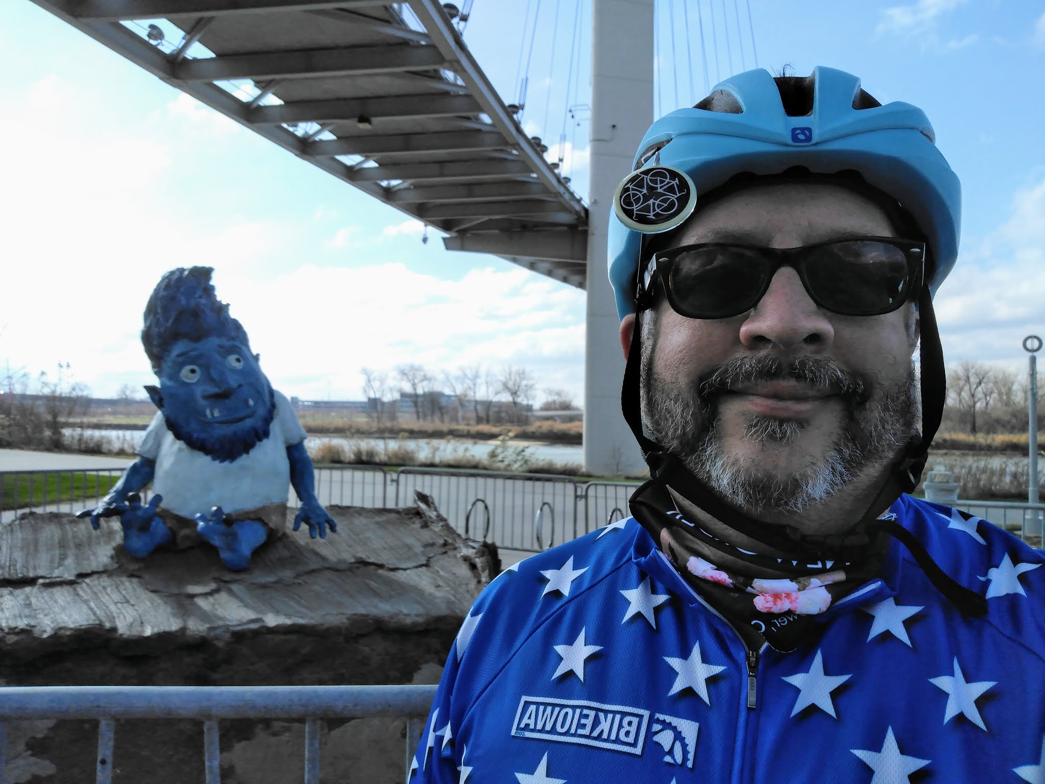
Omar the Troll. My QCR reader did not work for this. We saw this sign before we saw Omar underneath the bridge.
Bob Hope. Product placement 101. Reminded me of the depressing anti-suicide loud speaker broadcast at the Irvine Station Amtrak station in California.
Omar & Me.
The wind was stronger than the previous day and the sound of it blasting through the cables of the bridge was strange. At first I thought something was wrong with my bicycle. Oddly, no movement of the bridge unlike some other bridges we have been on. After crossing and returning to our native State we explored the trails and found a spectacular derelict rail bridge that some billionaire needs to finance the rehabilitation and conversion into a pedestrian/bicycling bridge. The Turnstile Bridge is a must visit!
In Council Bluffs after crossing the bridge.
In Council Bluffs. The top rotates.
I recall spotting this in the distance and thinking "I gotta go there!" Still owned by the Illinois Central railroad.
Just cut the trees down and rotate it. Add a bicycle surface and connect it to the Omaha Trail System...
We returned to Omaha and loaded our bikes back into the Honda and drove back to Iowa.
One Last Ride
The Rock Island Stone Arch Nature Trail is located in Shelby, Iowa, just off I-80. A mere 4 miles, it offers a a scene of farm fields and small town life as well as the stone arch bridge namesake and another bridge to visit. I spotted this on the map months ago and thought why not? Glad we did. So if you find yourself with a bicycle in your vehicle as you traverse that freeway please take the time to get a quick 8 miles in. Despite the now 26 mph wind from the south we enjoyed this paved trail. Park at the gas station/café at the exit and unload your bike. Do not take the gravel path heading into Shelby. That is not the trail. We discovered this accidentally but if you like a fast gravel path with lots of bumps and a few quickly climbs, by all means take it. PRO TIP: look at the satellite feature of Google Maps when in doubt.
The Stone Arch.
The top of the Stone Arch.
The view north of the Stone Arch.
The final bridge and the end of the trail.
It takes people to do nice things.
At the park along the trail, Shelby, IA.
At the trailhead of the Rock Island Stone Arch Trail, this sculpture pays homage to Iowa's agricultural economy/heritage. Notice the cow and pig in the cornstalk? Also notice how still the flags are? 26 mph south winds will do that!
It was a quick warm weekend, perhaps the last time we'll experience a weekend in the 70s until May 2021. We left a lot of exploration of Omaha's trails for future expeditions and we would like to return some day soon.


Damn, she just now noticed? Another great read with great pics.
ReplyDelete