

Saturday, I took advantage of an opportunity to ride on Iowa's first rail-to-trail, the Cinder Path. This was my third adventure on the unpaved trail that runs from Chariton to Humeston, IA.
The trail follows a branch line of the Chicago, Burlington and Quincy Railroad built in 1872 that ran between Chariton and St. Joseph, Missouri. The railroad later became the Burlington Northern Railroad, which abandoned the railbed in 1974. The Lucas County Conservation Board bought the corridor that same year and established the trail. *1
My first time on the trail was in July of 2016. *2 Our team, Mary's Heroes, were returning from The Ragbrai and hopped on the trail at its southern trailhead in Humeston, IA. Five of us on loaded touring bikes without fat offroad tires got as far as 2 miles before giving up and taking paved and wide shouldered highway 65. Our bicycles were not equipped with the proper tires and were too loaded and heavy for it. The trail surface at that end of the trail is essentially grass covering the rail ties.. The trail is groomed with lawn mowing equipment. In 2020 Mary and I returned on our touring tandem with 2.2 MTB tires and completed the entire trail although the southern section saw us in granny. *3 For Saturday's adventure I took my gravel bike with 700x37 tires and had no intention of riding the entire trail. My plan was to reach the covered bridge 6 miles out.
To make this ride more interesting was the rain. Not that it was asked for. Not that it was planned for. It just happened. Seems that every weekend it either rains or there is a 30 mph wind, both not conducive for enjoyable bicycling. The rain hit on the way to Chariton. On a narrow two lane highway I moved the wiper lever all the way down to fastest and desired another two levels of wiper speed. The giant Ford F-350 farmdozer with bison bumper guard on me arse was not welcome, but my high-profile vehicle managed its best with my precious cargo, my wife and two daughters who were going to Chariton for a bridal shower for my future daughter in-law. Interesting how we made it out of the last squall and dropped down a hill and instantly all the windows in my Pilot fogged up! 10°F temperature drop. Damn A/C! How all the rain from yesterday was to affect the trail I had no clue. I had a change of clothes and blankets to protect the Honda from a muddy bike. Yes, I was able to transport 4 people and the bike inside with only the third row of seats folded down. Bicycles are safest inside a vehicle. Dry, too. Dropping them off at the house hosting the shower I drove to the trail. I was told to be back in two hours. Plenty of time. The sun was out and so was the humidity.
The trailhead in Chariton is easy to find as it is right off highway 34 next to the Hardee's. Plenty of parking under shade trees. Expect to see people sitting in their vehicles having lunch or taking a break. Once on the trail I immediately noticed the fragrance of flowers and was glad that I took two Claritin when I woke up. The first bridge appears instantly and then the trail proper turns black from the cider surface. It looks like rocky dirt and mud but it was quite smooth and dry for an unpaved trail during rain season. I looked at my front tire and only the center showed evidence of moisture. No mud and nothing flying on my face. The trail surface absorbed all the water and sent it away. Nice!
 |
| Front tire barely dirty. The trail looks muddy but was not. Cinders make a nice surface. |
The trail has a shady canopy of trees and follows a river. Both shoulders have water either the river or drainage ditch. Sweet William, wild blue phlox, line the shoulders along with nettles. The only issue with the trail on the Chariton side is that there is a section, not long enough to perhaps a tenth of a mile, of fresher limestone. Thick and it will suck your tires into it. I noticed that the trail here is much lower than the shoulders so it was likely a repair of flood damage. Probably the only section of trail that is lower than the shoulders.
The first trail user I encountered was a rider of an e-Bike who was ready to roll when I pulled my car up. Never saw him again. Further along two women were on a bench. They were on hybrids/MTBs.

 |
| WALK THE PLANK, MATEY!! |

3 miles into it there is a lean-to off the trail that requires one to walk the plank. The plank is over the ditch that runs along the east shoulder of the trail, the Chariton River. Crossing it rewards the trail user with a couple of benches and shelter from the sun. Of course, I stopped and cursed myself that I did not bring a beer. The plank is narrow so be careful and looks like it may have 5 years left of use in this manner.
It was here that I encountered another cyclist. He was in his late teens or older on a Trek with flatbars and V-brakes, the rear disconnected. The bike was covered with orange mud from the road crossing of 460th St. Mud embedded from the tires to the bottom of the fork and brakes covered. When I returned I saw his tracks on 460th. Bad! Bummer for him but he should have picked up one of the plentiful available sticks and got that gooey gunk off so he could roll without frustration.


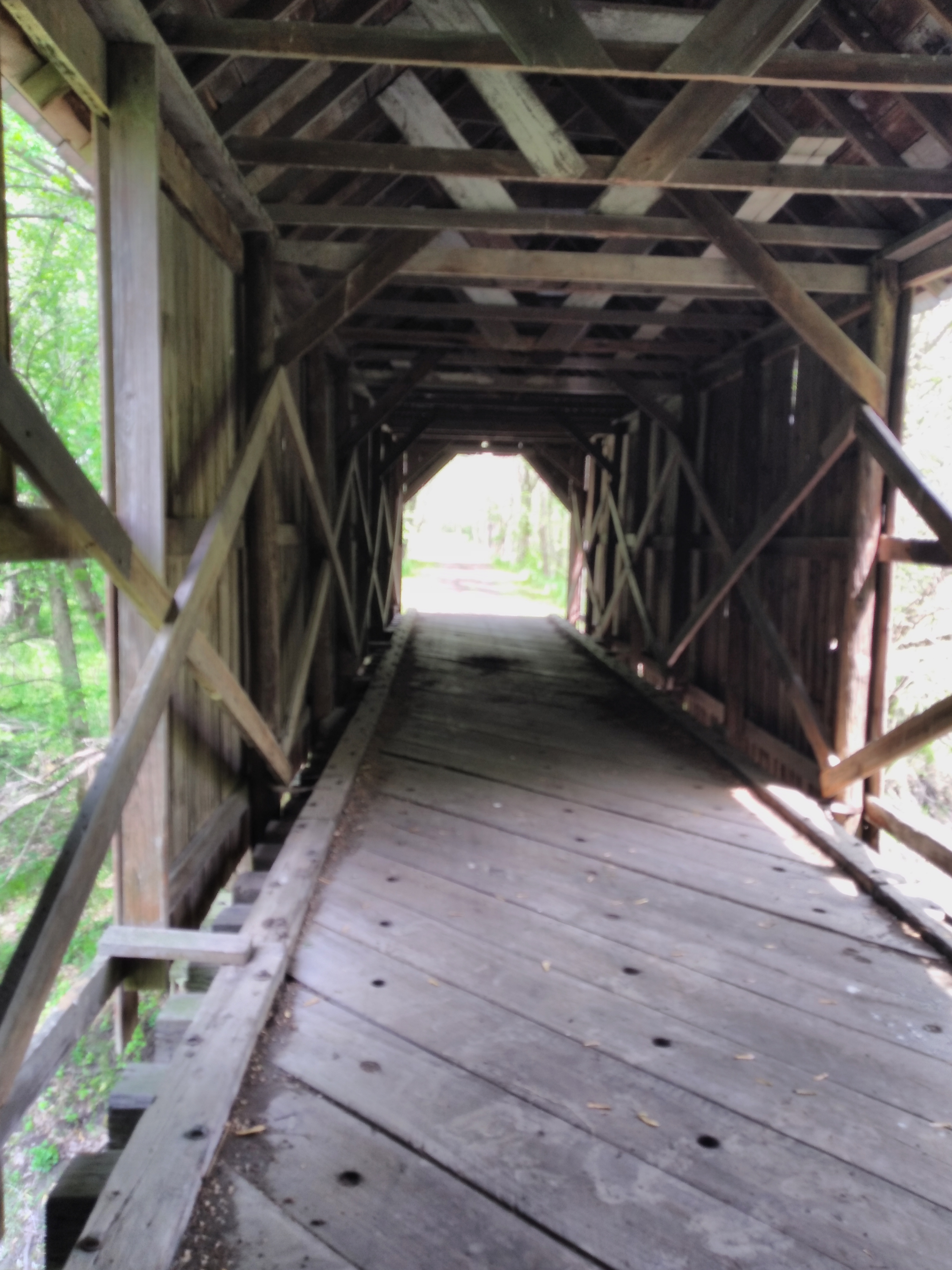
The highlight of the trail appears just beyond the 6 mile marker, a covered bridge. When we visited in 2020 the trail was closed on this section for road maintenance but we poached it anyway. This time the trail was open. The bridge is still in need of repairs. Part of the walls on both sides are missing. And several piles of what possibly is bat guano are in the middle of the road. Be careful where you step and ride. Also, there is a deer stand on the north side of the bridge to the west so do not dress up like a deer during hunting season.
 |
| Deer stand |
The way back was uneventful. More cyclists were encountered. The two women I saw at the first bench had made it to the plank lean-to. Another person I came across was at the parking lot putting his bike away. We both remarked on how good the trail was despite the rain. However, we did not discuss how the ride back was. It seemed to be uphill judging by my speed and effort. Not bad but noticeable. I did return tyo pick my family up slightly 2 hours after dropping them off. They were happy for me. Blue skies for the drive home.
 |
| Every bridge has this sign. Given the low guards on the bridges perhaps a good idea, one bad move and you're in the drink! I had zero issues with the surface of these bridges. |
I really want to return in the autumn to take advantage of the changing foliage. It would be beautiful. Perhaps to remember to smuggle a can of beer with me.
FURTHER READING
*1 Cinder Path | Iowa Trails | TrailLink
*2 Riding The Mindway: The Clockwise Swoop: Ragbrai 2016 (che-ridingthemindway.blogspot.com)
No comments:
Post a Comment